

About the series:
Rando Editions - Carte de randonnées
A series of hiking maps which cover both the French and the Spanish parts of the Pyrenées in the scale 1:50.000.
The maps have the most known hiking routes marked, along with many topographical features for example contours in an interval of twenty meters. Also marked on the maps are different kinds of leisure-time-activities as parachuting, golf courts, riding centres and ski runs, as well as a great amount of sights, like churces, historic ruins and classic chateauxs.
Furthermore the maps are very helpful if you are looking for a place to sleep, since they have both camping lots and hotels marked, along with areas of special natural beauty and the most interesting museums.
Nyheder (Se Alle)
-
 Dkr 299.00
 -
 Dkr 199.95
 -
 Dkr 149.95
 -

111 steder i Trekantområdet som du skal se
Dkr 249.95 -
 Dkr 149.95
 -
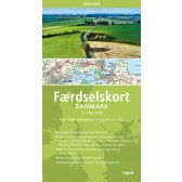
Færdselskort Danmark 2024-2025
Dkr 149.95 -
 Dkr 149.95
 -
 Dkr 149.95
 -

111 steder i Hamborg som du skal se
Dkr 249.00 -
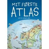
Mit første Atlas - lær om verdens lande
Dkr 199.95