Kortoversigt
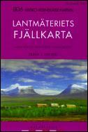
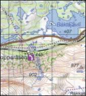
- Lantmæteriet Kartforlage - 1:100.000Lantmäteriet Fjällkartan The state run Swedish map publisher. Most of Sweden is covered by the series Terrängkartan (before Green kartan) in scale 1:50.000, all of the country in the series Vägkartan (before Blue kartan) in scale 1:100.000 and …versiktkartan (before Red kartan) in scale1:250.000. Besides this they produce a series "Fjällkartan" (hiking maps) in scale 1:100.000, covering the mountains towards the Norwegian boarder. These maps are good for hiking and for skiing. On each map is indicated summer and winter routes, hiking paths, huts and shelters. All maps comes in a plasticpocket. The same publisher also makes a roads atlas in scale 1:250.000 for the southern part and 1:400.000 for the northern part of the country. The maps have UTM net. The Fjällkartan cover the most popular hiking areas in the Northern Swedish mountains. They have hiking routes, shelters and lay-bys marked, and the informations about possibilities for activities help you to get the most out of your vacation. Pris: 140 kr. |
|
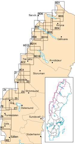
W1 = Grövelsjön-Lofsdalen
W2 = Fulufjället-Sälen
Z1 = Stekenjokk-Gäddede
Z2 = Borgafjäll-Risbäck
Z3 = Gäddede-Hotagsfjällen
Z4 = Skäckerfjällen-Kall
Z5 = Åkersjön-Kall
Z6 = Storlien-Vålådalen-Ljungdalen
Z7 = Åre-Vålådalen-Bydalen
Z8 = Helegs-Funäsdalen-Rogen
AC2 = Tärnaby-Hemavan-Ammarnäs
AC4 = Fatmomakke-Saxnäs
BD1 = Treriksröset-Råstojaure
BD3 = Rensjön-Pulsujärvi
BD4 = Kiruna
BD6 = Abisko-Kebnekaise-Narvik
BD7 = Sitasjaure-Ritsem
BD8 = Kebnekaise-Saltoloukta
BD9 = Padjelanta-Sulitelma
BD10 = Sareks nationalpark
BD14 = Kvikkjokk-Jäkkvik
BD16 = Vuoggatjålme-Ammarnäs
If you need help in finding the right map of an area, our map overviews can help you pick the right one.
Check out the map overviews