

About the series:
Freytag & Berndt - Road Atlas
Freytag & Berndt
Road Atlas
An Austrian publisher that publishes country and citymaps. The maps shows lattitude and longitude, and most of them has an index. They cover Europe and some countries in Africa, Middleeast and South East Asia. The scale depends on the size of the country. Further more there are more detailed maps to some Greek and Spanish islands, western Balkan, and roadatlas to Eastern Europe, Hungary, Czech Republic and Slovakia.
Nyheder (Se Alle)
-
 Dkr 149.95
 -
 Dkr 149.95
 -
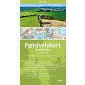
Færdselskort Danmark 2024-2025
Dkr 149.95 -
 Dkr 149.95
 -
 Dkr 199.95
 -
 Dkr 149.95
 -

111 steder i Hamborg som du skal se
Dkr 249.00 -

Mit første Atlas - lær om verdens lande
Dkr 199.95 -

111 steder i Trekantområdet som du skal se
Dkr 249.95 -
 Dkr 149.95